

Not all water access are the same! Though seemingly obvious, it has taken me a while to recognize this fact. Transferring my experiences into meaningful information has been a puzzle. For my canoe team to continue, I needed to effectively communicate what to expect at the launches and landings. Previously, I had not considered the launching or landing part of the canoeing event. These points were things that happened just before and right after the trip. Though these places are not considered features, landmarks or milestones of the journey, success can teeter on comprehending and maneuvering through these accesses.
I needed an easy way describe the water accesses. I figured out that saying "the launch and takeout are rough" was not descriptive enough. Despite the contemporary overuse of adverbs and profanity, graphic details are not much use either.
I would like to say I intentionally blazed a verbal trail to a new level of communication, but I have only borrowed and modified from a system of grading rapids. The spark of the notion came from a clever comment from a Houston Canoe Club article titled
"Miles and Mussels and Muscles #5 Brazos River, Hwy 290 to SH 159
August 4, 2018 by Natalie Wiest"
She states the following, "Not noted in trip description is the Class III put-in; and Class V takeout. Read, challenging, but well worth the effort." Natalie Wiest
I figure there are three factors in classifying an access.
1) Ease/difficulty of use
2) Stability of the access, dependent on environmental aspects.
3) Maintenance/cleanliness of the access
Hopefully my classification of water accesses will be useful. The definitions are intentionally simple; I only recognize class 1 through 4. Hopefully I can reference it in my future articles. Pictures can be effective communication tools, so I am including lots of them. Reading and viewing images is good, but being on location is best.
So here I go!
Class 1:
Class 1 launches are direct accesses to the water. Most of the time these incorporate paved roads and parking areas with concrete boat ramps. Staging room for the canoe and gear is a given. From a class 1 launch/landing an individual can solo overhead carry a tandem canoe to and from the water. Of course, it is always good to share the canoe load with a fellow team member, no matter how easy the access.
A plus is that these areas frequently adjoin parks incorporating bathrooms, picnic tables and grills. Consequently class 1 accesses typically receive high levels of maintenance. As such, they are usually clean of litter and clear of overgrown vegetation and graffiti. Until I experienced a string of trashed out and overgrown access and did some volunteer work on a trail, I didn't appreciate the effort and time required to maintain an access or the trail.
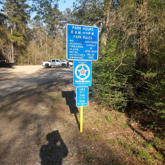
An example of a class 1 access is found at Bay Area Park in Pasadena, Texas. This is an access into the Armand Bayou system, please see the pictures below. The parking lot is adjacent to the launch. There are bathrooms, picnic tables and grills at this park.


Another example of a class 1 access is Howell's Riverfront in Columbus, Texas. Both of these accesses allow you to drive directly (or nearly so) to the banks.


Class 2:
A class 2 access is one with fewer improvements and increased difficulty compared a class 1. As class 2 access are more natural settings, weather events may have noticeable effects on these sites. To further define a class 2, they are under normal conditions only strenuous due to the length of the portage. These are not hazardous in regards of steep grades, twisted trails or trip hazards. A class 2 may demand a level of endurance, but they are not hazardous. A person should be able to single carry a tandem canoe on these trails.
Good examples of class 2 accesses are found along Spring Creek. Below are some images of the Riley Fuzzel canoe access in Houston, Texas.


The Riley Fuzzel access offers a paved road ending with a dirt footpath that leads down to the creekbank.
The example in the following images are from Spring Creek at the Carter Park canoe launch, also of Houston, Texas. The pictures are sequenced from the launch to the parking lot. The potential for a long portage is what makes the Carter Park Canoe launch a class 2. This trail is not technically difficult. The length may challenge some, especially if coordinating with the park for opening the gate doesn't work as planned. A canoe cart is nice for those with polyethylene canoes.
Saying that, I enjoyed the challenge and the workout! I bet folks canoeing the Boundary Waters or the Canadian wilderness would love a trail this smooth and level. Nice as it is, the Carter Park Canoe Launch is no a class 1 access. I have seen some kayakers distressed by this trail.


The first part of the Carter Park canoe launch, when used as a landing, is a natural trail that improves into an even dirt path. I believe this second part, the improved part, is an equestrian trail. The dirt trail leads to a blacktop bicycle trail which eventually leads to a parking lot. These paths runs through a scenic environment that is well maintained. The trail was long enough that I staged the gear along the portage. I set the canoe down at some point, went back to the creek and scooped up the remaining gear while Dottie caught an Uber to go pick up our van.
Class 3:
Class 3 accesses are basic, legal accesses. Unfortunately they often incorporating poorly maintained or "unofficial" roads. Class 3 accesses have steep, high river banks and are a challenge. For safety I double up on carrying the canoe on these escarpments. Either that or slide the canoe down or up the bank. These access points can rapidly deteriorate with rain.
Many of the Brazos accesses are a class 3. The Brazos River accesses at the Chappell Hill 290 (west bank), Hempstead 159 (east bank), Sunnyside 529 (east bank) and San Felipe 1458 (west bank) Bridges are all class 3s. It's worth noting that all these trails are at right angles to the river. Slanting the path angle 45 degrees or so could improve these paths. They would probably still be class 3 accesses, but...


Above are images of the 529 Sunnyside access trail. The portage is not long and the road is OK. The pictures do not portray the steepness encountered. With a casual observances you don't get the feeling its all that tough. It's when you have a canoe overhead and you are about to step across the peak of the precipice that these paths become most daunting. With your boots skidding over the loose dirt and the trail dumping into the river's edge at a right angle an ominous tone stains your thoughts. "This trail might not end well for me!" That is when the flourishing poison ivy is most apparent. The malaise deepens as you pick your path way through the concrete rip rap and steel rebar. But damn it, all that lies between you and the river is a piece of slanted ground that can be covered in a matter of minutes! An accidental slip down the bank with with a load overhead probably wont be life changing! Even so, a short term injury jeopardizes the trip. These thoughts flash in my mind, but I remember the warnings of Brother James about being double minded and his encouragement to perceiver. So far, I have avoided catastrophe.
At this point you may be thinking, "A class 3 access is too much trouble, too much risk, too much effort." We live in a culture of comfort and ease after all. However, if you push through to the other side you can experience the wildest remnants of Texas. Access is free, it just takes some grit, and it's yours to explore.
Class 3 accesses often see infrequent or zero maintenance and may have no amenities. Not even a trash can. I get it, why encourage dumping? I notice a marked increase in graffiti, litter and illegal dumping at these places. Though the condition of these areas is disturbing/perturbing, it helps me to remember these are portals to remote and isolated places.


The images above are of a launch from the west bank of the 290 Bridge at the Brazos.
I don't have a lot of pictures of these class 3 or 3+ accesses. Though these portages are usually brief in duration and distance, a class 3+ is especially unpleasant in the moment. Necessary parts of some trips, these are not places I linger. These passages are things to overcome and move on from. My experience at the class 3+ access at the 159 Brazos (east bank, near Hempstead, Texas) was intense. A "quintessential moment," I was too busy trying not to quit to snap a photo. However, where it not for that class 3+ segue from one realm to another that experience of myself would still be unknown.
Class 4:
A class 4 access is one that is impassable.
Sometimes weather conditions temporarily render a useable passage to a class 4. While I was working on a class 3 trail a twenty minute rain shower deteriorated the path to a point of uselessness. The class 3 deteriorated to a class 4. The exposed earth banks were just too steep, too high and too slick to ascend or descend. I wound up throwing my tools up the bank and using both hands for grabbing tree roots and grapevines to climb out.
This is where we need to be mindful. If an extended river camping trip ends during or after a recent rainstorm on a class 3 access, it would be good to have a backup plan. Some help, extra time or extra equipment would be wise. If it is a multiple night river trip it may be wise to adjust the trip, by allowing an extra day or shortening it as needed. Keep your options open.
So far my experiences and respect for the land and weather have guided me away from decayed class 3 access.
Most of my experience has been with class 1 and 2 accesses. My start to any class three access begins with respect and knowledge of the land, myself and my team members abilities and limits.
Thanks for reading.
Below are some pictures and descriptions, enjoy.
Examples of Class 1 Accesses:
The concrete apron on the Highway 377 Bridge over the South Llano River makes for a super nice place to launch a canoe. This is outside the town of Junction, Texas.


Though not an overarching structure, this 377 Bridge access to the South Llano allows a high degree of safety regarding motor traffic. This access, like the South Llano River itself was very clean. A nice place to launch a canoe.


Examples of Class 2 Accesses:


Examples of Temporarily Deteriorated Accesses:
To avoid ending on a sour note I am inserting the temporarily deteriorated accesses between the class 2 and 3 access examples.
Below is the Bay Area Park lamp at an extremely low tide. This happens when strong north winds combines with a low tide.

Below is an example of a class 2 at the Texas state highway 60 Bridge over the San Bernard River near Wallis, Texas. Typical of a class 2, the banks are not domineering, they are neither high or steep. Absent are amenities such as bathrooms, tables, grills, trash cans...
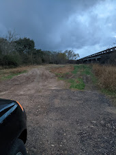
The three images directly below were taken under normal conditions. These photos were taken January of 2022. Not evident in the images is the basic road; the asphalt easement plays out quickly after turning off the highway. After that the "road" is unimproved, meaning it is packed dirt with no gravel. Under fair weather it's an easy enough drive, just avoid the ruts and holes.


Come spring, we made a relatively easy launch.


A little rain and the road surface deteriorates, resulting in a class 2+. For me, that means parking the van on the pavement and footing the gear from there. Not all class 2 accesses are susceptible to weather changes but its worth keeping in mind. The banks of the San Bernard would not become overly hazardous, but rains wont make traversing the unimproved road and trails any easier.
The lower three images were taken of the same San Bernard access after a summer thunderstorm. A high clearance four wheel drive vehicle could have managed, but the fragile "road" would be damaged.


I hesitate to publish pictures like the next ones, below. A unique but common issue that temporarily deteriorates access is illustrated in them.
I was scouting an access when I came across this mess. This class 3 access on the Brazos was degraded by illegal dumping. Depending on your situation and temperament this is a class 3+ to a 4.
Yes, those are animal carcasses directly across the trail. Not only were both animals wasted, the deer was killed out of season. I was able to pick my way around and step over the mess, but had I been packing gear it would have been more difficult. There was no alternate path under this bridge. I guess I would overcome these obstacles but, what a mess! Where there is a will a way can be forced, but I am not normally prepared for dealing with rotting and bloated carcasses. These biohazards are unfortunately too common. I figure this is the work of locals who are serial dumpers.


Class 3 Accesses:
Back to more pleasant things!


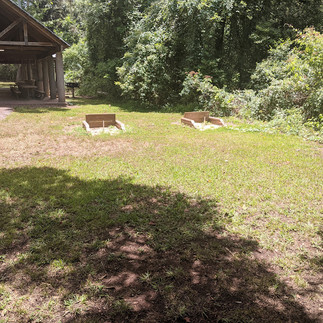
Above are images of the access at the trailhead of the Columbia Bottomland Waterway, the uppermost segment of the Stephen F. Austin Paddling Trail. This is probably a class 3. Unusual for a class 3, this trail is adjacent to a park, Brazos River County Park. Part of the Brazoria County Parks Department, this park is well maintained, scenic and outfitted with all the amenities. Some of the parks features are pictured below.


Below are some photos of maintenance on what is likely another class 3 access trail. This access the trails end of the Columbia Bottomland Waterway, in East Columbia, Texas.


I am pretty sure the Texas Parks and Wildlife and various coastal municipalities were overwhelmed by the floodwaters from Hurricane Harvey and the 2020 shutdown.
A special thanks to Kevin Burns' leadership and coordination, and to Bob Stone's participation in the maintenance of this access trail!
The Brazos is a special Texas river, ever changing. Building and maintaining semi permanent river access on these steep banks is always challenging. If you feel like volunteering to help maintain the access trails and parks on the Columbia Bottomland Waterway (part of the Stephen F. Austin Paddle Trail) contact Kevin Burns at kevinkeithburns@gmail.com
Below are pictures of progress on the access path at trails end of the Columbia Bottomland Waterway. With the exception of a chainsaw, all the work was done with manual tools.


Below are pictures of the Colorado River at the Garwood Bridge, a mild class 3 access.


More than any other access, I am aware the class 3 paths are passages from one realm to another. These are the last places under the hands of men, even if their efforts are sometimes uncoordinated and crude. The best marks on the land are always gentle and from those who enjoy the outdoors. The other marks, I endure like the brief hardship and hazards I chance. The eyesores I ignore. Beyond these rough stations the riparian edge, that thin strip of limited wilderness awaits you.
Please see the links at the bottom of this page for details on some Texas river accesses.


Brazos River Accesses:
Colorado River Accesses:
Trinity River Accesses:
This is so helpful! At 67 years of age getting up the bank WITHOUT a canoe can be challenging, so knowing the level of challenge can make a big difference deciding where to put in and takeout from the waterway. Prior recons are needed to gather this info and decimate to those planning on joining the excursion.