

Armand Bayou Access & Water Details
- Scott and Dottie Moore
- Aug 7, 2023
- 12 min read
Welcome to The Urban Frontier blog!
My agenda is to promote outdoor activities in a natural setting with a base of experience and truth that is sustainable and honors God. Seeking to build a heritage, I strive to avoid polarizing language and phrases that recklessly ricochet through the internet. I am not promoting a political view, extreme lifestyles, seeking an echo chamber or to change someone's entrenched world views. If I have not done it or witnessed it, I wont write about it. That means my blogs are published sporadically.
A friend of mine coined a phrase, saying "Scott, we are extremely serious casual fishermen." At first I recoiled but quickly accepted the truth and chuckled. Being a casual, amateur, or non-professional outdoorsman, there are many folks more experienced and advanced than me in the outdoors. No matter, my hope is this writing will have a narrow but deep impact, rather than being broad based and shallow.
Seeking sustainability means most of my outdoor adventures are in nearby regions. Now and again I venture further out, but for the most part I keep within a 100 mile radius of my Houston home. Houston is not known as an outdoor destination but there are beautiful areas within and nearby that are surprisingly remote and isolated. Armand Bayou is one of these, a refreshing oasis in a desert of concrete and steel.
Enjoy the article below!
Armand Bayou, a Brief introduction
Many readers will be familiar with this water. The source of Armand Bayou is in the south east part of Pasadena, Texas. Considering that this stream is in a megalopolis, its relative natural state, remoteness and isolation are remarkable. Motorboats are largely prohibited from these waters.
One dreary, rainy Saturday morning while canoeing this water, team member Bob asked "Scott, where is everybody?" Earlier that morning we had paddled through a light mist under gloomy clouds. Recalling the light drizzle I glanced at the improving sky and remarked that "I usually see a kayak or three out here. It looked like rain earlier. Most people probably stayed in." That is when Bob restated his observation, exclaiming, "Scott, we are in a community of three or four million people! There is no one is out here. Even on days like this there should be someone out here!"
On sunny days it is not unusual to encounter a few people on these waters, but Bob's observation was spot on. Should you visit these waters, a unique and personal Harris County outdoor experience awaits. My observation is this stream is one of the more isolated and remote in Harris County. For canoes and kayak people, its also one of the easier waters to access.

This article builds on notions and concepts from previous entries. For better understanding, click on the following underlined links explaining river access ratings and scouting in the articles Classification of Water Accesses and Scouting River Bridges & Accesses.
My article Armand Bayou Accesses and Water Details has quick links regarding passages further down in the body. Click on those links below to skip down, scroll down or just read through for the bonus material for the satellite images and descriptions of Armand Bayou.
Quick Links:
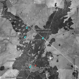
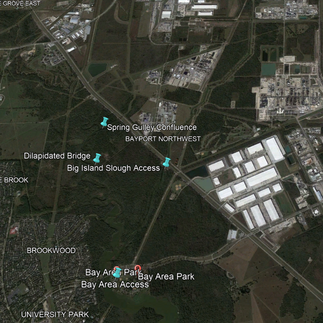
Bay Area Park Access:
Over the years I have used two accesses to Armand Bayou and its associated waters. Of the two, the launch at Bay Area Park is the oldest and is usually the easiest to use. This is a class 1 access. The paved parking area extends directly to a concrete launch. There is room to stage your equipment at or near the water.


Bay Area Park has a police presence. Vandalism and illegal dumping are not issues. I park vehicles without concern. There are multiple picnic tables and grills at this park. The bathrooms are clean when I visit.
The Bay Area launch is unique among class 1 accesses in that tidal flows can deteriorate launching or landing. When strong north winds combine with very low tides using this access becomes questionable. I have seen where others persevered through the mud, but when the tide is that far out I use the Big Island Slough access.


Park at Big Island Slough Access:
The small park on Big Island Slough offers a more rustic ingress into the Armand Bayou water ways. This is a short class 2 launch. When the tides are way out this access is easier to use than the one at Bay Area Park. I also use this launch when I want to avoid the winds on the more open waters of the lower bayou.


This park is on both sides of the channel. Parking is also on both sides. A pedestrian bridge links them but vehicles must utilize Red Bluff Road to access the other side of the park. There is a floating kayak launch on the west bank but I use the access on the east bank.
Though there is a concrete ramp on the east side I prefer to launch and land just downstream. There is room to stage equipment at or near the water. I appreciate the crushed granite that stabilizes this portion of the bank.

As with Bay Area Park this access is clean and free of vandalism and illegal dumping. There is a port-O-can restroom and picnic tables.


Thanks for reading.
Bonus pictures and water descriptions below!
Bonus Material - Water Description

Armand Bayou is a brackish waterway in Harris County, Texas. Waters joining Armand Bayou are Spring Gulley, Big Island Slough and Horsepen Bayou. As Armand Bayou increases on its path it becomes Lake Mark Kramer. This portion of the water was recently known as Mud Lake.
These waters rise and fall with the tide of the Gulf of Mexico; stream direction is directed by tidal flow. There are no rapids and currents are not strong. As such single point launching and landing is preferred. Parts of these waters lie in a game preserve where gasoline powered boats are restricted. These factors and logistics only add to the appeal of these waters for canoes or kayaks folks.
As these waters lay in beds of mud there are no sandbars or gravelbars. Egressing at areas other than the provided launches is challenging to unpleasant, depending on your demeanor. Fortunately there is no need to portage or line the canoe after launching.
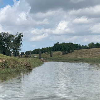
On the water the aggressive urban development is soon forgotten. Decades of high altitude photographs and satellite images reveal the changes brought by development and subsidence. For this article high altitude photographs and satellite images as far back as 1944 are available.
Below are two sets of three images of the Armand Bayou system. Those directly below are of the upper navigable part. Left to right the pictures are December 1944, December 1978 and April 2022.


The next three images are of the lower Armand Bayou. The dates are the same. I don't hear much about subsidence these days, but the general notion was that wells and the refineries water use were the cause. I suspect this is part of the reason Lake Houston was formed in the mid 1950's, Lake Livingston in the 1960's and Lake Conroe in the early 1970s.


More subtle changes are an increasing alligator population and a thickening surrounding wood. On the water the thick woods absorb many of the urban noises and obscure much of the development.
The oldest images have been helpful. They reveal the yet existing original bayou channels. When the tides are out I seek those channels to avoid grounding on the deep mud flats beneath the shallow waters.
Some Pictures and Thoughts on Alligators:
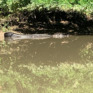
Especially during low tide, you will see alligators in the Armand waterways and on the banks. For some there is an innate curiosity in being in the presence of these apex predators. Many folks are either over or under respectful of these creatures. I suspect these animals have for better or worse, been socialized. Best practice is to not provoke them, and give them space. I have gotten to where I ignore them even while I mark their position and monitor their response to my disturbance.
I consider alligators opportunistic feeders, figuring they are usually hungry but not always hunting. They run on hybrid fuel, what they eat and sunshine. They seem to bask as much as anything else, absorbing energy from the sun to help power their cold blooded bodies. As cold blooded animals they require far less food intake than warm blooded predators.
Alligators are opportunistic short-range ambush hunters. I suspect they are also scavengers. They may sniff out a dead carcass to feed upon but I doubt alligators sniff, track and pursue live prey as the great cats and wolves do.
In late summer some alligators become aggressive. If they are guarding a nest they will be more aware of and less tolerant of your presence. At these times they would rather you leave than linger. Their way of making their will known is subtle but convincing.

During late August and early September I avoid the narrower passages and tributaries of Armand Bayou.


The cow skeleton on the right was an interesting find. The legs were gone. I figured it died from disease or age, and the alligators twisted off the legs and ate them.
I have seen alligators sunning on winter mornings that had been as cool as 39 degrees. When the morning warmed and the sunshine came out, so did the alligators!
Armand Bayou:
Armand Bayou, formerly known as Middle Bayou, was named after Armand Yramategui, a Hispanic native Houstonian who taught at the Houston Museum of Natural Science. He was also a curator of the Baker Planetarium.
Bay Area Park is located on the banks or Armand Bayou and is adjacent to the Armand Bayou Nature Center. Wikipedia notes the "... 2,500-acre (10 km2) nature center is the largest urban wilderness preserve in the United States" (emphasis mine). Wow!
Unlike some other natural parks in the Houston/Harris County area, there are few trails following the banks of the Armand waters. For the canoe team, Armand Bayou offers several connected water ways to explore. As mentioned above, some of the named ones are Spring Gulley, Big Island Slough, Horsepen Bayou and Mark Kramer Lake.
My pattern of writing follows an uppermost stream access as a starting point and I work downstream. For this article I will start "upstream," but bear in mind the Armand Bayou network of streams is different; the weak and changing currents combined with two launch sites less than two miles apart make A-to-B paddling unnecessary. It's nice not to need a shuttle on a canoeing excursion!
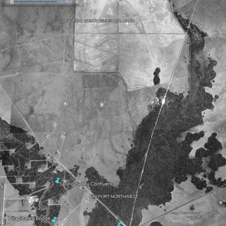
The furthest up Armand Bayou I have paddled has been within a mile downstream of the Genoa Red Bluff Road Bridge. A heavy rain coincided with a high tide to make that trip possible. The channel there is small and the bayou feels remote and isolated. Above Spring Gulley this part of the bayou is most like itself before the subsidence.
Near Spring Gulley and below, Armand Bayou begins to widen. Compared to old photos the bayou looks to be running high. Though the bayou follows its original channel it is increasingly out of its bed.
By the time it reaches Big Island Slough the water is broad. At this confluence and in other places it helps to know where the original channels lie for ease of passage. At high tide one can canoe over the flats without concern. Stray out of that channel during a lower tide and an unknowing canoe team may find themselves unintentionally beached on a shallowly submerged mud flat. From experience I now know the mud is deep and best avoided.
Not far from the Big Island Slough confluence the bayou crosses under the Bay Area Boulevard Bridge. Immediately downstream the bridge Bay Area Park is on the left/north bank. About a mile down on the right/west side lies the hidden mouth of Horsepen Bayou.
Further seaward Armand Bayou steadily increases and straightens, forming Lake Mark Kramer.
All these waters are murky but at times they possess some clearness. This is the home of mullet, turtle, gar, catfish, snake and alligator. On the banks we have seen deer, feral hog, racoons, squirrels (grey and fox squirrel species) and armadillos. All manner of birds are present. I have identified spoonbills, egrets, great herons, green herons, kingfishers, pileated woodpeckers, osprey, migratory waterfowl and the various species hawks. The banks of these streams are graced with palmettos, pines, oaks, tallow, elms and ash trees.
Spring Gulley:
The most upstream Armand Bayou tributary I have explored is Spring Gulley. Though the navigable part of this stream is shorter than 1/4 mile, it is a fun place to be and a good way to add some time to a trip.
The volume of water that Spring Gulley contributes to Armand Bayou is small and the increase in the bayou is a result of the sunken bed. Spring Gulley was straightened above the Red Bluff Bridge before 1944. Below Red Bluff Road the channel was straightened before 1978. Red Bluff Bridge is my turn around.


The images above are dated 1944, 1978 and 2022. Spring Gulley is barely noticeable in the 1944 photo. Google Earth has this tributary incorrectly labeled Armand Bayou. The photos directly below are of from a trip that included this stream.


Big Island Slough:
The bayou's increase below Big Island Slough is significant. As with Spring Gulley, subsidence is the source for the increased stream volume.


The high altitude aircraft photos/satellite images above are of the confluence of Big Island Slough into Armand Bayou over the decades.


Nature is reclaiming the portion of Big Island Slough from Red Buff to the confluence. I see alligators from time to time on this section of water. Fortunately the stream is wide enough to keep man and beast at the appropriate social distances!


The images above reveal the progression surrounding the portion of Big Island Slough above Red Bluff Road.
The upper reaches of Big Island Slough was straightened before 1944. The lower part was straightened between 1953 and 1978. Images below are of a trip on the upper parts of this stream. Under the right conditions I have canoed as the Fairmont Parkway Bridge.
Should you want to minimize exposure to alligators I have seen few if any of those creatures on the upper parts of Big Island Slough. They are adaptable animals of course, but they prefer more gradual banks and tall grass/plants to tunnel through.


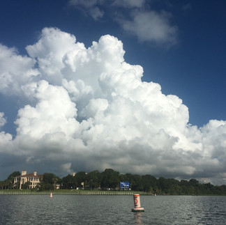
A mix of the natural and industrial, the upper Big Island Slough is a maintained landscape and is worth exploring. It's nice to stretch your eyes over a distance and a manicured expanse, take in the blue sky and coastal cotton candy clouds on a summer evening. Spending time on this water has a calming effect on me. Traveling by canoe allows you to be present and feel part of the environment.
Horsepen Bayou:
Further downstream is the mouth of Horsepen Bayou. Old photos reveal the channel above the Middle Brook Bridge has been straightened. The lower part of this Bayou remains in its natural bed. The mouth and some portions of Horsepen have a high concentration of alligators.


Canoeing upstream, Horsepen Bayou is crossed by Middlebrook Drive, University Drive and then Bay Area Boulevard. Using Bay Area Boulevard as a turn around the Horsepen Bayou adds a little more than 3-1/2 miles to your trip. Though the images above reveal extensive urban development, the view from the canoe is good.


If remoteness were measured by distances from structures then the Horsepen is less remote than the upper Armand. If isolation is measured by lack of boat traffic on the water, then Horsepen Bayou is more isolated.

Anyone on the Horsepen Bayou is not there casually. On the water, finding the mouth of the Horsepen bayou is tricky. The confluence of the Horsepen is concealed by a cove. The smallness of the channel, the largeness of the cove, barrier islands and submerged mud flats camouflage and deter ingress to this delightful stream. Beyond the Bay Area Bridge the riparian edge gives way to urban development.

Lake Mark Kramer:
Below Horsepen Bayou Armand Bayou continues to increases. Above Lake Mark Kramer the bayou is permanently and far out of its original bed. The winding channel exists beneath the surface but the waters above straighten the path. Eventually Armand Bayou becomes Lake Mark Kramer. Here the water becomes very wide. Be mindful that power boats will have limited access to this lake.


Without subsidence Lake Mark Kramer would be a slither of its current capacity. This big water contributes to the diversity of Armand Bayou. Adding this lake to a day trip allows one to experience a larger water and the small streams of the upper Armand Bayou. Let the environmental factors determine your launch location and course. If tides are low, launch from Big Island Slough. If winds are mild venture into Kramer Lake. In windy conditions seek the sheltered smaller waters, or test your metal and challenge the choppy open waters.


Kramer Lake adds depth of experience to the day tripping excursion.


Threats to Armand Bayou:
Though subsidence is arrested, development is still an issue for Armand Bayou and its associated waters. It's not just the urban sprawl but the ancillary effects of light and noise pollution and the eyesore of plastic liter. Plastic refuse on these waters is low to moderate with higher concentrations in the upstream portions nearest the bridges. Sometimes heavy rains and runoffs increase the plastic pollution in the stream.


Some of the abundant aquatic plant life is invasive and thriving. I suspect much of the fuel for these plants is lawn fertilizer that washes into these streams from the neighborhoods. There are also invasive animals in the Armand Bayou ecosystem, the most infamous are the apple snail and feral hog. Like the man made structures I suspect these introduced plants and animals are here to stay. There may be no way to know the animals and plants that are no longer present in this watershed.


Below is a "mot" of invasive elephant ears plants and an alligator.
My take on this water is this. Its an altered but beautiful world. I am glad to have easy and nearby access. Canoeing through through this remnant of a coastal prairie is worth the visit. I have been here many times and hope to return again and again.

Comments