Brazos River Access Detail: The Simonton 1093 Bridge
- Scott and Dottie Moore
- Mar 5, 2023
- 4 min read
Updated: Dec 10, 2023
A few miles from Simonton, Texas the FM 1093 Bridge crosses the Brazos River.

Hurricane Harvey and other factors made this access a faded facsimile of its former self. My last surveillance of this sight revealed a long portage from the parking area to the river bank. This is a class 3 access. There are no public bathrooms, picnic tables or grills. For explanation of river accesses ratings please read the articles Classification of Water Accesses and Scouting River Bridges & Accesses. As this detail reveals, class 3 accesses are subject to change; this one especially so. Best practice is to scout the area prior to use.
The approach for this access is from the north east bank. The access road parallels the highway to a barricaded parking area near the abutment of the bridge.


Currently there is a small parking area at the ramp of the bridge. In the past the barricades blocked the passage from the parking station to the easement to the river. That has been opened.
From there the access passes under the bridge then goes straight down to the river.

The easement is improved with asphalt. Though I have witnessed a high clearance 4 x 4 traverse the entry, I see this as portal for pedestrian traffic from the mechanical and societal state to a more natural realm. From here it is a fairly lengthy portage to the river bank. The heavier the canoe the longer the portage!

I could crab about these access but as I have written elsewhere, Canadians would think such a level and straight portage heavenly. We have nothing to harp about. Even if they are vague, Texas laws are generous in allowing us access to the rivers. We wish for easier and especially cleaner accesses that are not vandalized. The reality is these are examples of a few week willed folks and the county governments responses. I like to think we are capable of self government. I guess as long as we have legal access to the rivers there is evidence of a level of trust and good will that remains.
Apparently this access was once a part of a Brazos River Paddling Trail. Other existing Brazos River paddling trails are the four part Stephen F. Austin Paddling Trail in Brazoria County and the Bosque Bluffs and Brazos Bridges paddling trails in Waco. This section of the Brazos is not currently sponsored by the Texas Parks and Wildlife Department.

So far, so good. It nothing but a long class 2. Then we come to the bank.

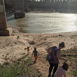
No hill for a stepper, but if you are packing a canoe and other gear down or up this unimproved trail a different opinion might arise! Add some rain and things get really interesting!
These obstacles overcome, the peace of the river awaits you. Just upstream the bridge the current can be swift, but along the sandbar the river is gentle. Be aware of the hazard of slippery banks, lodged water logged trees and those powerful currents. Don't be fooled, just because the Brazos does not appear swift does not mean it is not powerful. As always in any moving waters monitor children closely.
Rivers are not like lakes, ponds or pools. They are forces of murky power urbanized folks frequently fail to recognize. The pictures below are of the same access taken only six days later than those above. I would not launch a canoe with the river at that stage! The places my children played were well under water.
Upstream the next access is more than sixteen and a half miles away, the I-10 Bridge. Nearly eight miles downstream lies the Orchard 1489 Bridge.
For details on other river accesses please see the bottom of the article Classifications of Water Accesses.
Thanks for reading!
MSM
Update December 2023 ~You Win Some, You loose Some
You never step into the same river twice. Proof is in the images I took August of '23 of the Brazos at the 1093 Bridge. This is the reason you scout class 3 accesses before a trip!
Wood has been collecting at this site for years. At the time of these photos this acces was not suitable for launching canoes and kayaks. If a team were super determined, and I mean, super determined, they could use it, but it looked hazardous if not dangerous. I would not use the access in this condition unless I was in a super desperate situation.
The 1093 Simonton Access is a big place. I was not able to get the entire site in one picture that made sense, thus the multiple photos. Looking at the picturs now, I am not certain the they are 100% convincing. Being there was convincing though.
There was a Bobcat skid steer loader (mini bulldozer) chained to one of the bridge peers on the upper bank. Some of the tracks in the pictures appear to be from that equipment. Hopefully they were able to clear some of the debris and make this location usable.
I have seen comments on some forums criticisng overviews of river accesses. Things change, especially rivers. Properties are sold, fences go up, sandbars slip away or slide up. In this case the tree carcassas have piled up, along with some garbage. Checking on class 3 accessess should be part of the trip plan. If you plan on paddling a river with class 3 accesses, it is your responsibility to check them out, or to have a back up plan that includes more time and distance.
On the plus side, the access road had been smoothed out and I was able to drive my van down to the top of the bank. Very nice! I am grateful for any improvements that slide my way!

Thanks for reading!
MSM


Comments