Recon of the West Fork of the San Jacinto River
- Scott and Dottie Moore

- Mar 24, 2024
- 11 min read
The call of the West Fork of the San Jacinto River lay unanswered a long time. Then, March of 2024 things lined up for me and that eerie and stricken stream. Starting at the 59 Bridge, my brother and I made a nanoscopic odyssey. We canoed five miles upstream, turned back and landed at our launch.
Like many of my river trips the impression of this excursion lingered for several days. I noticed it on my morning commute when my gaze fell on a greenspace. Many times I had driven by this place but now I recognized something in it I hadn't before. Staring without focus, the remnant patch snagged my subliminal awareness. It was an ignored strip of land between the railway and highway. Though I appreciate planned and maintained landscapes of evenly spaced trees of similar kind and age with sculpted shrubs and cut grass, there was something tragic and courageous about this piece of feral land.
Long neglected by the eyes and hands of men, all manner of unchecked botanical growth springs ungroomed and free. Here the blade of the mower and shredder are never applied! The desirable grass species are choked out by the salt brush, senna bean and other tall, stalky, woody weeds. In the undergrowth a discerning eye spies dewberry, briars, grapevines, poison ivy and thistles. In the spring, weedy wildflowers, the Indian blankets, pink ladies and prairie winecups thrive in these uncut spaces. Summertime brings the fiercely blooming sunflower. All the trees here are undesirable species and volunteer. These uneven efflorescence outcast are plotted and planted by the experts, the birds and winds. Here I find the elm, tallows, mulberry and the hackberry stretching for the clouds. If there is water nearby I sometimes find the cottonwood, willow or sycamore.
Early spring these places are more grey and brown than green. The branches of the various species of trees reveal the different structure and patterns of their trunks and branches. I wonder "which of these are indigenous and which are invasive?" and "What would these lots look like left to their own another few years?" It's a cyclical and reoccurring mental pattern for me. It occurs without my cognizance and takes about twenty seconds for the cycle to complete if traffic doesn't interfere. Wait, maybe traffic is part of the process? Probably, this happens a couple times a week.
No matter, the pattern changed a few days after the San Jac WF Recon. The mental iceberg flipped, if you will. I realized these little pieces of feral ground were the incomplete remains and disjointed components of a scattered wilderness that are yet trying to regrow, reform and remerge. These so called trash or undesirable species are the pioneering plants, the first to recover ground. These are the plants that prepare the way for more "enduring" species. It doesn't matter if its a fallow piece of ground or land laid open by a river, this is the pattern of recovery. The weeds, the vines, the stalky things and fast growing trees, they do this regardless of the hopelessness, broken and shattered state of the environment. This...this, was the hook that dredged up the subconscious notions, and connected these different but mirrored mental processes. This feral sanctum reminded me of my recon of the West Fork of the San Jacinto River!
I only gradually learned about the San Jacinto River. Years ago one of my Spring Creek canoeing trips ended on that river at the 59 Bridge. On the Spring, miles before I could see it, I heard the din of traffic on that bridge. The San Jacinto River West Fork (SJWF) below the mouth of the Spring was wider than anything I was used to! I knew I wanted to explore this river.
There is little to no information on accessing the SJWF. Only a little more is written about paddling it. The bits I found were not encouraging. Additionally, satellite images though honest, were disheartening. Revealing aggressive and extensive urban and industrial development, these images, along with questionable and un-scouted accesses led to delaying my exploration of this river.
On that first jaunt on the San Jacinto I knew it was a large stream at the 59 Bridge. However, a cursory glance from Google Earth of the river further up convinced me it was a small stream. My eye was less trained then. This was also before I comprehended the importance of the cubic feet per second measurements of the various stream gauges.
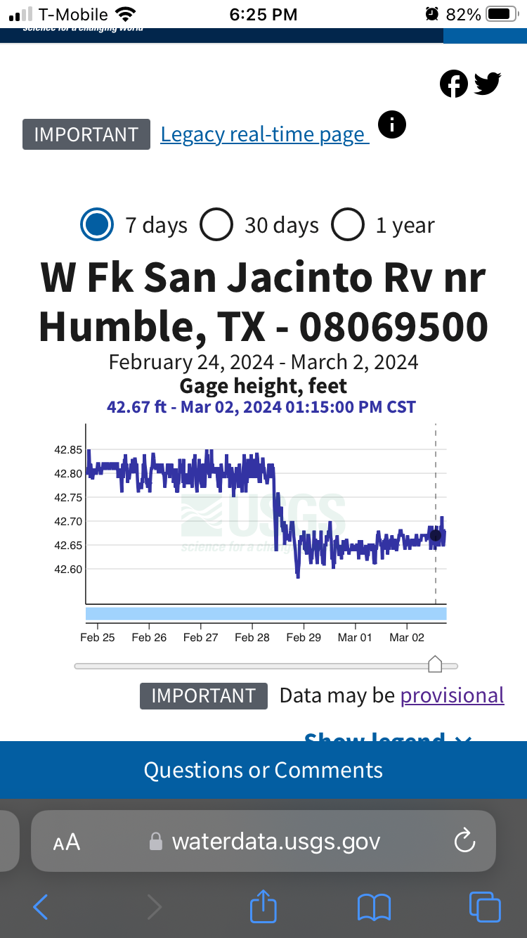
For years other streams held my interest. Then, prolonged rough circumstances forced me to seek waters near my home. Especially waters with single point entrances and exits were of interest; I needed a place to canoe without a shuttle. January 20th 2024, Dave G, my daughter Crystal and I spent the day scouting various accesses on the west fork of the San Jacinto River. January 26, 2024 the SJWF at the 99 Bridge crested at 81.99 feet, a mild flood stage. This was far above the normal 56-1/2 feet. The river stayed high into late February.
After I canoed enough waters and studied enough gauges, and scouted enough accesses, and especially after scouting those accesses on the SJWF, my impression of that river shifted. Now I questioned what I read about it. I knew I'd have to canoe this river before I could write of it with conviction. The January scouting solidified my notion of an upstream recon from the 59 Bridge. I new currents at the 59 Bridge, and about 2-1/2 miles up, were often slack. I also knew from scouting the 99 Bridge and multiple places upstream, that the currents were strong. What I witnessed was incongruent with the text advising the SJWF was "slow and meandering." Other on line research indicated frequent linings should be expected and suggested it best to run this river on a rise.
I don't mind lining a canoe and it's difficult to time running a river when it is only a foot or so higher than normal. For the recon, I was determined to see the SJWF at a normal stage. Think of it as a scientific "control."
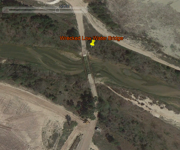
Figuring we would encounter a thwarting current at some point, I hoped we could reach the remnants of a wrecked low water bridge about five miles up from the 59 Bridge.
On the water nearly all of the development was obscured from view. It's almost a form of delusion, except beauty is in the eye of the beholder. Here is an opportunity to choose what we see. For this trip, I decided a certain way, and I am confident it was best for me in the moment and the now.
March 2nd at 10:35 am with the SJWF running at a normal 56.58' at the 99 Bridge, my brother and I launched from the 59 Bridge. The din of traffic snuffed pleasant communication. Our conversations were with raised voices of spartanly phrased commands with single word responses. Despite the noise, bank fishermen worked both sides of the river. Our farewell party consisted of a friendly stray cat.
We quickly crossed the river. Here the confluence of Spring Creek and the San Jacinto River amalgamate and pile up with the effects of the Lake Houston Dam. The river is very broad and stock-still here, but evidence of recent high waters remains stacked against the piers and pile caps of the 59 Bridge.
With a gentle breeze on our backs I wondered if it wouldn't be a headwind on our return. Above the Spring confluence the San Jacinto channel narrowed, changing from that broad watercourse that ushers to Lake Houston.
Sadly there are two dumps along the eastern bank within the first mile. Though the river is noticeably smaller than at the 59 Bridge, the channel is still decently wide and it seems deep. As we progressed upstream plastic pollution continued but diminished.
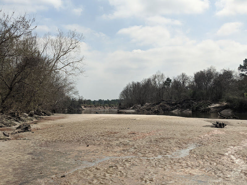
I hadn't canoed this water previously but there seemed to be recent and generous sand deposits everywhere.
At 11:30, about 2-1/2 miles we came up to what I call the Riverview Access. I had hoped this could be used as a drop point access to launch and land a canoe. A determined individual could use the place to prove a point, but I'd rather paddle the extra 2-1/2 miles from the 59 Bridge.
Compare the sand deposits in the two photos below. These are of the same place, one image taken from the bank on January 20th, the other taken from the water March 2nd. Mark the leaning tree.
In the photo above there is a piece of something, maybe a sleeping bag, hung on a tree limb from higher waters.
A few hundred yards above the Riverview Access is a park with concrete boat launch. I had driven by the park on the January scout. At the time the gate was shut and locked, so we drove to the next location. In my satellite survey I hadn't noticed the boat ramp. This reminded me there is measurable value in witnessing something the flesh. In careful re-examination of satellite images I found the concrete structure I had overlooked. The limits of exploration by satellite would be a reoccurring theme of this adventure.
The day of the recon we saw bank fishermen at the Riverview Access and the park. The park warrants another scouting trip for me!
Onward we canoed. At noon, about 3-1/2 miles from our launch we took a break on an unexpected inferior sandbar. Like the boat ramp at the park, I had overlooked this low sandbar in using Google Earth. To be fair, the sandbar doesn't appear until you zoom in quite a bit. Regardless, the SJWF is healthier than I imagined! Apparently the sandbars shift and slide about quite a bit on this river.
We spent about an hour and a half in this rich place, a longer than normal break. Upriver we had seen Bonaparte's gulls, brown pelicans, wood ducks, kingfishers, great herons and a bald eagle. On this sandbar we discovered various animal tracks.
For a shattered wilderness the place has an abundance of wildlife! The animals are likely crowded into a diminishing habitat. Clearly these wilderness components are larger and more complete than those I find on my commute, but in looking at the satellite images and in being here, I can tell these pieces are striving to rejoin, reform and remerge after what has and is happening.
We ate a hearty snack and drank some water there. A small boat with two fishermen gingerly navigated the increasingly narrow and twisting stream.
The SJWF was beginning to look more it's natural self, like the parts I had observed on my upstream scouting. The bed became sandier, the stream began to narrow and more readily twist. Now the plastic pollution was decreased. Though encountered less and less, my nemesis the plastic bag, marked the high waters by clinging to the tree limbs here and there. I did not photograph these eye sores, but if they wound up in a photo I didn't cull the image.
By this time I began to notice the bluffs were higher and the gravel and sandbars were longer than I expected from a river this size. My suspicion that this was not a small stream but a minor/medium sized river was confirmed, at least the parts I canoed. My observance of this and other East Texas rivers and their gauge history indicates they run high during the winter and into spring, falling into a "normal" level the rest of the year.
That would explain what was to me, the disproportionately large features of this river. The high bluffs and large sandbars compared to the width and volume of this river under so called normal conditions begin to settle into my mind of what is the SJWF.
Upon deciding to relaunch I took notice of something different. A tiny snag near the sandbar bent under the strain of current! I advised Todd, adding that I hoped we could make it as far as the Wrecked Bridge.
Venturing further upstream I was aware the SJWF's current. Some places the current was slack or nearly so, but where the channel narrowed the current became forceful. We passed a group of happy and courteous fishermen in one swift place. They didn't have to do it, but they generously coached us through the swifts, advising us where the barely submerged sandbar lay.
Further up we encountered another swift. I think we could have overcome it but the canoe ground out on a gravel bar. We lined the canoe a short distance, the riverbed was soft even though it was composed of gravel. When the water got deeper we re-entered the canoe. From here for at least the next five hundred yards or more the current was swift. Sprinting through this stretch some tall gravel pit equipment loomed into the view. A large diameter pipe stood fast in the river and before I knew it we were beyond the wrecked bridge. Kind of anticlimactic; if I hadn't studied the satellite images I would never have known the structure had existed. A victory for the SJWF against progression!
As we crossed over the remnants of the bridge another sandbar emerged upstream. The further up we went and the further we got from the Lake Houston Dam, the more natural the SJWF became. The head of this sandbar, unlike the first one we stopped on, was a gravel bar.
We made my goal. At about 1:30 pm we cooked a hearty lunch.
I intended to photograph the skillet and contents, but hunger got the better of us. Some of my camp cooking polish had lost its sheen, but the meal turned out great. We ate it all.
In rinsing out the pan and bowls my personal phone slipped out of my shirt pocket, right into the river. So my pictures from that moment forward are absent. Fortunately after drying for a couple days my phone was salvaged!
By now it was 3:00 or so, fairly late in the day. Even with the sound of the gravel pit in the back ground I didn't want to leave the place. But I knew we needed to return. We hadn't planned or brought any camp gear. As beautiful as this sandbar was, I prefer a more remote campsite; we were just a hundred yards or so from the gravel pit. At least we had the return trip to look forward to. But I dallied. I wanted to prolong the visit to this place.
Returning, the trip was uneventful, without lining or a break. Some bank fishermen waved at us as we passed over the wrecked bridge, likely they were employees of the gravel pit. Closer to the 59 Bridge someone's radio was playing loudly in the distance. Traffic noises increased as we neared the confluence of the Spring. The tailwind was now a headwind, a little stronger in the evening than the morning. We made it back to the 59 Bridge by 4:30. I guess the current was stronger than I realized.
My Takeaway
From scouting the accesses I knew something was special about this river. Standing on the riverbanks in January was a foretaste that satellite images and other text could not convey. Even in the dead of winter I felt I was in the presence of something indifferent to the point of defiance. The SJWF is wild yet and in God's will. Canoeing, this stream and I made a different exchange. Something of the SJWF mingled with me and passed to me. The spirit of that river lingered for days. The essence of it was only realized in degrees. It took writing this article for me to find the right word.
Haunted.
Yeah, that's the word. But it's not what you think. It's not haunted by some wicked spirit threatening from the other side. Contrarily, these chopped up scraps of wilderness, the remnant glory of the San Jacinto West Fork that are clinging to existence, these are the things that haunt me. The threatened and thinning riparian edges of the SJWF are yet the habitat of deer, beaver, waterfowl, eagles, alligators and many other critters. Maybe our spirits are what haunt the river.
The SJWF is a deeply damaged river. Even so it is persisting under pressure and threat from urban and industrial development. I understand we all need a place to live, water to drink and concrete to build with, but I hope we can preserve the remains of the SJWF. They are a confined destruction, dreadful and devastating and fragile and wounded and fierce and beautiful all at once, and worth canoeing.
"Against its will, everything on earth was subjected to God's curse. All creation anticipates the day when it will join God's children in glorious freedom from death and decay. For we know that all creation has been groaning as in the pains of childbirth right up to the present time." (Romans 8: 20 - 22 New Living Translation 1996)
Surely the San Jacinto River is groaning under the levy of the fall.
Thanks for reading.
MSM
Below are some bonus photos and links to articles that detail certain aspects mentioned in this article.
The effects of Lake Houston are evident in the various measurements illustrated below, but most easily understood by seeing the water.
The Google Earth images, the stream gauges, the images and text I present are valuable and useful tools, but they don't compare to being on the west fork of the San Jacinto River.
I want to canoe the SJWF before more development takes place.


Comments