

The Spring Creek Access & Water Details is my continuation to the promotion of sustainable canoeing activities. As a serious casual outdoorsman, my writing is based on truth and experience rather than knowledge and agenda.

For me, sustainable canoeing centers on waters in or near Harris county, Texas. Sustainable canoeing incorporates other outdoor activities that involve minimal planning and preparation, on a light budget. It's not that travel, forethought, equipment and money are not required or that a day needn't be set aside. These things, and being prepared, are necessary for success. Put another way, this is a lifestyle, not a spontaneous and new one day event/undertaking.
In reality, the practice of the sustainable is moving forward with the application of concessions. Concession is the palatable re-spelling of the word compromise. Oftentimes the grass really is, greener some place else. There are costs associated with that greener grass though. I prefer canoeing as often as possible, as opposed to saving up for a once in a lifetime trip to Canada. Most canoeing choices are not that stark, but you get the idea.
Concerning Spring Creek, in the concession and bartering of items of proximity and convenience...we yet manage to secure a high degree of beauty and serenity with a taste of isolation and remoteness. The compromises are obvious enough that writing about them is not necessary. I am blessed to live near Spring Creek and its comfortable charm.
Welcome to The Urban Frontier Blog. You can read the article through or use the quick links below. As you wish!
Spring Creek, an Introduction
Spring Creek is a frisky, small Texas stream running through the trace remnants of a vast East Texas wood. Today it servs as the northern boundary of Harris County. I am most familiar with this creek from the Riley Fuzzel Access down to and past its confluence into the west fork of the San Jacinto River.

A clean and beautiful stream, Spring Creek is a recognized treasure. Harris County has bejeweled the southern bank of the Spring by beading it with parks and lining it with trails. The bed of this creek is primarily sand mixed with a light scattering of gravel. Running through a wood of pine, cottonwood, sycamore, cypress and ash, the channel turns and runs between sandbars that alternate from one side of the creek to the other. Low bluffs and high pines grace its banks. In spite of the development along the Spring I have seen bald eagles, nutria, pileated woodpeckers, kingfishes and various cranes. Deer tracks are easily found. Sightings of feral hogs and coyote would not surprise me.
Above the mouth of Cypress Creek the Spring is a small stream. If a fallen tree can span a running water, its a small stream. Not every part of Spring Creek is that narrow, and there are other denotations that I use to define a stream small. Spring Creek meets all those parameters. For a better understanding of stream sizes please read the article Stream Size Definitions.

At any rate, above the Cypress the Spring has a playful and dynamic current. Do not be discouraged by the small size of the Spring above Cypress Creek. It is strikingly beautiful and an excellent introduction to this water. Frequent linings can be expected but the sandbars are generous and frequent. Its easy to imagine you are in a much more remote and isolated place.
The sandy bed makes the required and repetitive linings of the canoe nicer. At normal stages a canoe team can use this water to learn to read currents, observe small eddies, lean to get in and out and line the canoe while developing communication and teamwork skills.
Below the mouth of the Cypress, Spring Creek's volume increases and the experience changes. Here, unless the creek is very low, lining the canoe is not required. As the Spring moves towards the San Jacinto River, the creek continues to widen and its current slows. The sandbars diminish in number and size and the bed silts up. This is the effect of the Springs merger with the larger San Jacinto River which is in turn altered by the dam downstream that forms Lake Houston.

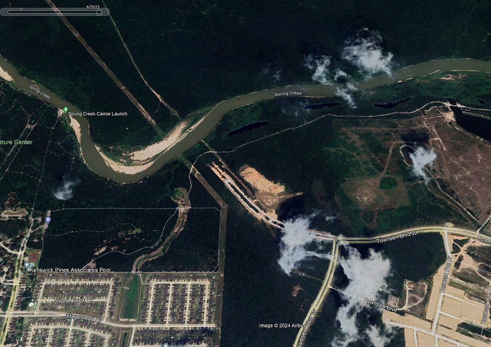
Satellite images reveal development is progressive, extensive, aggressive and advancing in the watershed of Spring Creek.
The dichotomy of the natural riparian edge of Spring Creek and the advancing urban sprawl does not conjure collocations. For me, writing about the Spring summons awkward phrases I won't use, like "wilderness/metroplex" or "developed primeval woods." Even as development encroaches, the park systems (which are a byproduct of the population that creates the urban sprawl and pollution) helps preserve its natural look and feel. Maybe you can't have your cake and eat it too, but Spring Creek is in a nicer state than the channelized solutions seen on other Houston area bayous and creeks.
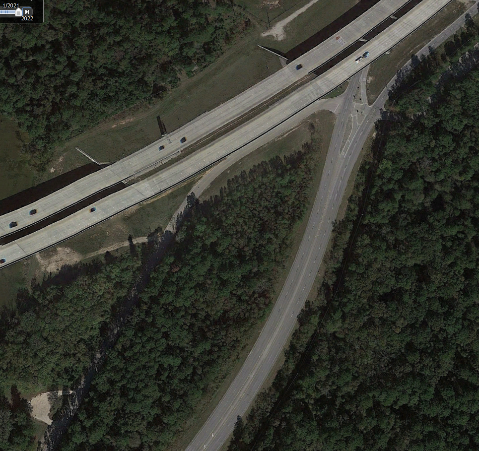
Bridges are a form of development. The correlation with development and urban refuse is strong. Whether it is premeditated dumping or opportunistic litterbugs, graffiti or noise pollution, all manner of adulteration collects at bridges. On the Spring, plastic litter is light, probably because so few bridges cross this creek.


The satellite images above are dated, left to right from 2004, 2012 and 2023. Despite the thinning margins, Spring Creek remains a canoeing gem of Harris County.
The Bayou Land Conservancy states that "The Spring Creek Greenway is the longest, connected, urban forested corridor in the nation," and its watershed is defined by the Harris County Flood Control, as "...mostly undeveloped." After viewing satellite images I challenge the undeveloped notion combined with the word watershed. It is more accurate to say Spring Creek is left in its natural bed.
The trails along the creek bank for earth treaders witness an understandably high volume of traffic. It is after all "...the longest, connected, urban forested corridor in the nation..." and its southern bank is laced with parks and trails. When canoeing Spring Creek you will join fishermen, hikers, bicyclist, equestrians, photographers and picnickers. By and by you will see plastic refuse on the Spring, but the plastic liter volume is low considering the proximity to the powerhouse megalopolis of Houston. Near the bridges noise pollution especially, pierces and punctuates the environment. The noise may ruin the moment but these rackets contrast the riparian environment and remind me how special Spring Creek is.
The lower Spring Creek provides short to medium length day trips with class 2 accesses supported by a park system. The numerous sandbars are a delight to disembark for stretching your legs, adventure picnicking, fishing and changing stations in the canoe. I have seen neither alligator nor motor boat on the Spring though I imagine both are increasingly possible below Jesse H. Jones Park.

Overview of the Accesses Along the Lower Spring Creek
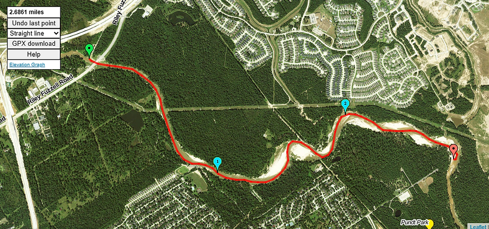
With the Riley Fuzzel and San Jacinto West Fork accesses there are five ingresses to to the lower Spring Creek. Between the Riley Fuzzel and San Jacinto are three parks, Pundt Park, Carter Park and Jesse H. Jones Park. The parks are linked by a network of trails. The last take out is not on the Spring but the San Jacinto River west fork. Launching from Riley Fuzzel and taking out at the 59 Bridge on the San Jacinto is 13+ mile canoe trip.
Thanks to a police presence in the parks, vandalism and illegal dumping are largely absent from the lower Spring Creek. Leaving a vehicle at the parks of Spring Creek is not a worry.
Due to the small stream size the challenges of class 3 accesses are not present on the this water. All of the Lower Spring Creek accesses listed are class 1 or 2. Some of the trails are long but they are predominantly paved or improved and relatively flat. Sometimes arrangements with the parks can be made for automobiles to access the paved portions. This shortens the portage. For an understanding of access click on the following links, Classification of Water Accesses and Scouting River Bridges & Accesses.

A canoe cart works well on these trails.

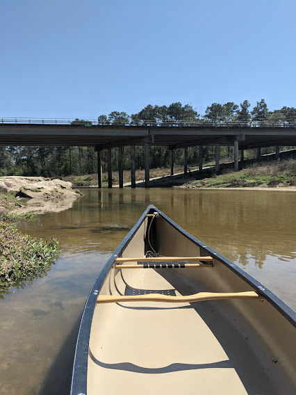
The images below are from the Pundt Park canoe launch when the creek was on a rise. You don't need a canoe to enjoy these sites!


ACCESS DETAILS
Quick Links to Spring Creek Accesses
Detail of the Riley Fuzzel Access
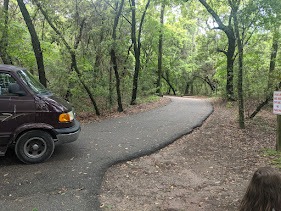
The most upstream access of Spring Creek I have used and scouted is the Riley Fuzzel Bridge. This bridge is a little downstream from the 99 Tollway overpass.
The roadway to the Riley Fuzzel launch is a tangle. Once through the maze there is an asphalt road and parking area. Note that various maps use different spellings for Riley Fuzzel.


From the parking area the pavement extends to an unimproved trail that leads down a fairly steep bank to the creek bed. This is a class 2 access.


As this access is not to or on a sandbar the unimproved trail is subject to temporary deterioration with inclement weather. When I visit this access I have not seen vandalism or dumping. For a waterway near so much development, Spring Creek is remarkably clean of liter. At this site there are no picnic tables, grills, water fountains or restrooms.
The next downstream access is about 2-1/2 miles away, the Pundt Park Canoe Launch.
Pundt Park is a large facility with high traffic. Approaching from upstream you may recognize the Pundt Park canoe launch by the people enjoying that sandbar.

Detail of the Pundt Park Access
Pundt Park is the next access down from Riley Fuzzel.


At Pundt Park there is an asphalt drive with a loop to the canoe launch. From the gate to the creek is a couple hundred yards. Other than the Riley Fuzzel launch this is one of the shorter portages on the Spring Creek.
This is a class 2 access. Because this access is on a sandbar and the slope is gentle, it's unlikely to degrade from a modest rain.


A county park, we see hikers, fishermen, photographers and picnicking families enjoying this launch.
Pundt Park is a large facility with a high volume of visitors. I am thankful for the police, they are the reason dumping and vandalism are not present at the park. I don't worry about leaving a vehicle unattended at Pundt Park. After canoeing the Brazos and using its class 3 accesses I especially appreciate the clean and secure parks with their amenities along the Spring! This park has a playground, picnic tables, grills and restrooms.
The next downstream launch is just over 4-1/2 miles away, Carter Park. If you are planning on ending a trip at Carter Park, watch for a single blue sign mounted on a yellow pole. All the accesses of Spring Creek are on your right as you head downstream.

In approaching Carter Park from upstream there may not be any people marking the launch at the sandbar. So keep an eye out for the yellow pole with the blue sign!

Detail of the Carter Park Access

Carter Park is the next downstream access from Pundt. A small facility, the volume of Carter park is lower than the other two parks. There is a well maintained restroom and an archery range. Like the other facilities along the Spring, a police presence helps makes the place secure and clear of the crimes of vandalism, dumping and so forth.


Upon entering the park there is a short asphalt drive alongside a gravel parking lot. There is a gate on the drive at the east end of the parking lot. The portage trail starts at that gate. Arrangements can be made to have the gate unlocked, but I just walk around it.

This asphalt road continues, eventually crossing a biking trail. The portage trail continues on the other side of the biking trail. Beyond the paved bike trail the path is improved, and broad, clear of obstructions. Continuing on the trail leads to a good sized and gentle sandbar on Spring Creek. This, is the Carter Creek canoe launch. One of the longer portages of the Spring Creek, the effort rewards you with opportunities of a lightly paddled stream.

This as a class 2 access. As this access is on a sandbar and the elevation grade is low, it is unlikely to deteriorate from isolated thundershowers. From Carter the next assess is at Jesse H. Jones Park, roughly 3-3/4 miles down stream. From the water the Jones access is easy to spot.


Detail of the Jesse H. Jones Park Access
Jesse H. Jones Park is the lowest access on Spring Creek. The significance of this park is reflected in its concrete access to the creek. Only momentous drought or flood could temporarily degrade this access. Coordinate with park officials and its possible to drive nearly to the water, making this a class 1 access. Without that coordination its a kind of long class 2.
Jesse H. Jones Park and Nature Center, like Pundt Park is a large, high volume park with a strong police presence. There are also bathrooms, picnic tables and grills.


The next downstream takeout is the 59 Bridge on the West Fork of the San Jacinto River. Coming from upstream it is impossible to overlook this takeout! You will hear it long before you see it.

Detail of the 59 Bridge & San Jacinto River West Fork Access
Though its not on the creek, the 59 Bridge over the west fork of the San Jacinto River is a viable access for Spring Creek. This is a class 2 access. From the highway I usually miss the correct exit, but the second approach to this landing is not overly complex. It's just big and different, kind of like driving in downtown Houston, or something. Anyway, the takeout is on the southeast quadrant of the bridge. This is a big access.

It's also a bit of a variable. Scout it before using it. Sometimes it is more open than other times.


In January of 2024 parts of this access were closed. When the accesses that shorten the portage are closed there is still parking under the bridge.
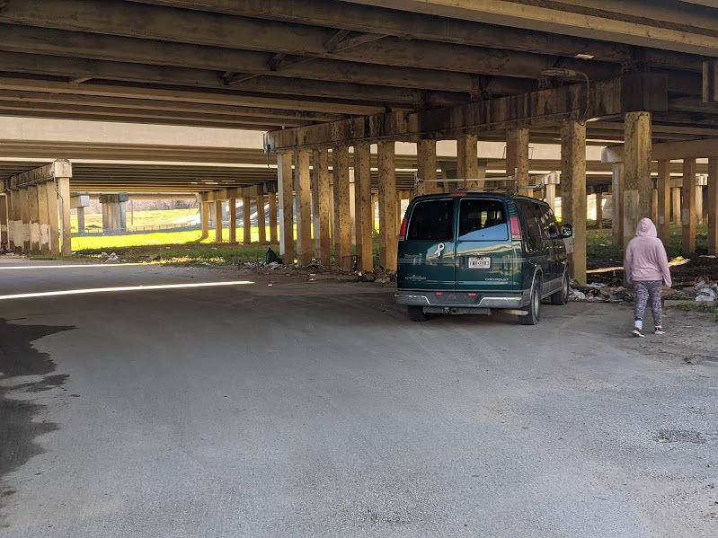
Like the Riley Fuzzel Spring Creek access, and unlike the park in Pundt, Carter and Jesse H Jones, the 59 West Fork San Jacinto is a socially free, if not feral place.


When I revisited this access in March of 2024 the gate was unexpectedly and happily, open! With the gate open you can park your vehicle closer to the river. My March San Jac recon followed directly after a minor flood, so there was a lot of soft sand deposited. It was everywhere, including under the bridge and covering the paved road and parking surfaces. I suspect there was always asphalt under my van, but the sand was probably two feet on top of the road in places. Even four wheel drive vehicles struggle in soft sand!
I am always straightforward concerning the eyesores of illegally dumped garbage, graffiti and plain old liter. This access has it all! Its one thing to see it in a photo, quite another to be in it. Speaking of the different pollutions, this is the loudest bridge I have been under! Ear plugs are not a bad idea here, seriously.
There are no restrooms, grills, or picnic tables here.

Spring Creek and the associated waters are a beautiful and surprisingly natural canoeing venue.
Thanks for reading!
MSM
Bonus articles on canoeing Spring Creek and SJWF are listed below.
コメント