Trinity River Access Detail: The Goodrich 3278 Bridge
- Scott and Dottie Moore
- Mar 4, 2023
- 3 min read
Updated: Jan 18
To see the update to this access please click on the ink above. It will take you to that section of the article.
To read about a November day tour from this bridge click on the link below.
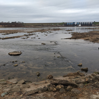
About five road miles west from the town of Goodrich, Texas the FM 3278 crosses the Trinity River. This bridge is within sight of the Lake Livingston Dam.


The 3278 Bridge is unique in that both sides of the river are usable for launching a canoe. Both the 3278 access are class 1. For explanation of river accesses ratings please read the articles Classification of Water Accesses and Scouting River Bridges & Accesses.

When visiting this site make sure to check in at the Bowder's Marina before entering park.

The west bank access is the larger area with paved roads, multiple trash cans and a restroom. There was no restroom I saw on the east side of the river.
Both accesses are commonly managed. I am not used to paying for access, but it throttles the abuse many other river accesses suffer. I would leave a vehicle for the day, especially on the west bank access.
The accesses are marked with clear and easily understood signs. The building above, far right is the restroom on the west bank, a nice amenity.
The images above are of and from the larger access of the west bank.


Either access is a good place to start your adventure of the lower Trinity River. The next access is nine and a half river miles down, the Goodrich 59 Bridge. The images below are from the east bank.
For details on other river accesses please see the bottom of the article Classifications of Water Accesses.
Thanks for reading!
MSM
Update, December 2024
From December 28th 2023 to August 5th of 2024 the Trinity River remained too high for canoeing. The river hit flood stage in January of 2024. In May of that year the river hit flood stage again. It stayed at flood stage for 22 days. It crested at 48.3' on May 4th and peak volume flowed 139,000 cubic feet per second.

On November 23rd 2024 I made a recon of the lower Trinity River. The trip started at the 3278 Bridge and ended at the 59 Bridge. At this time the weir below directly below the dam appeared repaired. Heavy equipment was still staged there. It was Saturday, the crews may have had the weekend off.
Pictures below are before and after the 2024 floods. The images below left and center are from Google Earth and Channel 2 News. The 3278 Bridge is in view on the bottom right is my picture.
Some of the Browder Marina facilities on the west bank of the Trinity at the 3278 Bridge were damaged, gone, or removed. In the images below are some pictures I took from the west bank. The left image is where I remember the restroom and cleaning station, the center picture is the closed boat ramp and the picture on the right is of the bridge repair.
I was not scouting the accesses when I made this trip so my details are not complete. We were not able to launch from the west bank. As the middle picture above indicates, the boat ramp on the west bank was closed. There were folks fishing on this bank.
We launched from the east bank. My brief observation was the east bank facility was intact.
Well, hopefully this is helpful!
Thanks for reading!
MSM


Comentarios